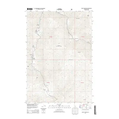
2013 Map of Teapot Mountain
USGS Topo · Published 2013About this map
The South Fork Salmon River carves a deep valley through this portion of the Payette National Forest, serving as the primary geographical corridor for remote airstrips and forest access. Points of interest like the Krassel USFS Airport and Reed Ranch Airport highlight the reliance on backcountry aviation in this steep terrain. The river is fed by numerous tributaries including Indian Cr, Buckhorn Cr, and Phoebe Cr, creating a network of drainage basins that define the local topography.
Find a feature on this map
44 named features on this map. Tap any name to fly to it.
Don’t see what you’re looking for? This feature index may not catch every label — zoom into the map to look around manually.
Map Details
Editions of this 2013 Teapot Mountain Map
This is the sole edition of this map. No revisions or reprints were ever made.
Other maps of this area

1956 · Elk City
USGS Topo · 1:250,000

1957 · Challis
USGS Topo · 1:250,000

1960 · Elk City
USGS Topo · 1:250,000

1960 · Challis
USGS Topo · 1:250,000

1963 · Challis
USGS Topo · 1:250,000
1969 · Enos Lake
USGS Topo · 1:24,000
1969 · Parks Peak
USGS Topo · 1:24,000
1969 · Williams Peak
USGS Topo · 1:24,000
1973 · Blackmare
USGS Topo · 1:24,000
1973 · White Rock Peak
USGS Topo · 1:24,000