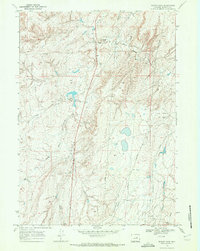
1968 Map of Teapot Rock
USGS Topo · Published 1972About this map
Teapot Rock stands as a prominent geologic landmark in this late 1960s survey of the Wyoming high plains, a region characterized by its early-established ranching industry and burgeoning energy sector. The landscape is defined by the drainage basins of Teapot Creek, including its East Fork, and Horse Ranch Creek. The map documents the physical footprint of the region's petroleum development, showing the Twentymile Oil Field and various Oil Field infrastructures alongside the more traditional pastoral holdings of Burke Ranch and Teapot Ranch. A network of pipelines and a Radio Facility at the southern edge of the sheet indicate the modernization of this industrial corridor. Water management for the semi-arid terrain is evident in features like the Benton Reservoir and the rugged contours of Twentymile Hill and Stave Gulch.
Find a feature on this map
12 named features on this map. Tap any name to fly to it.
Don’t see what you’re looking for? This feature index may not catch every label — zoom into the map to look around manually.
Map Details
Editions of this 1968 Teapot Rock Map
2 editions found
Other maps of this area

1955 · Arminto
USGS Topo · 1:250,000

1958 · Arminto
USGS Topo · 1:250,000

1959 · Edgerton
USGS Topo · 1:62,500

1959 · Ormsby Draw
USGS Topo · 1:62,500

1962 · Arminto
USGS Topo · 1:250,000

1968 · Big Gulch
USGS Topo · 1:24,000

1968 · Illco
USGS Topo · 1:24,000

1968 · Salt Creek
USGS Topo · 1:24,000
1968 · Statzer Point
USGS Topo · 1:24,000
1968 · Mc Pherson Draw
USGS Topo · 1:24,000