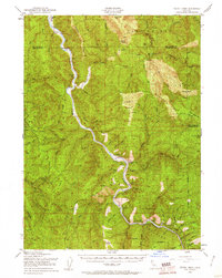
1952 Map of Tectah Creek
USGS Topo · Published 1961About this map
The Klamath River winds through the heart of this mid-century survey, defining the life and movement of northern Humboldt County before modern development. Small riverside nodes like Johnsons and the Pecwan Union School serve as local anchors, while family-named landmarks such as Mc Covey Ranch and Starwein Flat reflect the area's homesteading and ranching legacy. The terrain is deeply carved by numerous tributaries, including Tectah Creek, Pecwan Creek, and the expansive Blue Creek system, which flows from the high ridges of the Six Rivers National Forest. This era shows a landscape managed for timber and traditional use, with limited access provided by State Route 96 and primitive roads reaching remote spots like Bukers Prairie and Cappell Flat. The map effectively captures the transition from isolated wilderness to a more documented backcountry.
Find a feature on this map
44 named features on this map. Tap any name to fly to it.
Don’t see what you’re looking for? This feature index may not catch every label — zoom into the map to look around manually.
Map Details
Editions of this 1952 Tectah Creek Map
3 editions found

Other maps of this area

1922 · Preston Peak
USGS Topo · 1:125,000

1925 · Hoopa
USGS Topo · 1:125,000

1929 · Crescent City
USGS Topo · 1:125,000

1945 · Ship Mountain
USGS Topo · 1:62,500

1945 · Orick
USGS Topo · 1:62,500

1945 · Trinidad
USGS Topo · 1:62,500

1945 · Coyote Peak
USGS Topo · 1:62,500

1945 · Requa
USGS Topo · 1:62,500

1945 · Tectah Creek
USGS Topo · 1:62,500

1948 · Weed
USGS Topo · 1:250,000