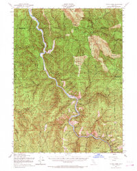
1952 Map of Tectah Creek
USGS Topo · Published 1968About this map
The Klamath River carves a deep path through the northern California wilderness in this mid-century survey, revealing a landscape defined by isolated homesteads and river-dependent settlements. Family-named landmarks such as Mc Covey Ranch and Johnson are situated along the riverbanks, while the Pecwan Union School serves the small communities scattered throughout the Six Rivers National Forest. This era shows the region before extensive modernization, with travel limited to the Bald Hills Road and rugged trails connecting upland prairies like Bukers Prairie and Pit Place Prairie. The map documents the intricate drainage network of the Yurok ancestral lands, including Tectah Creek and Blue Creek, where the Blue Creek Lodge offered a rare outpost for visitors. The terrain is marked by high ridgelines such as Pecwan Ridge and Hochter Ridge, which flank the river and shelter numerous small gulches and flats.
Find a feature on this map
39 named features on this map. Tap any name to fly to it.
Don’t see what you’re looking for? This feature index may not catch every label — zoom into the map to look around manually.
Map Details
Editions of this 1952 Tectah Creek Map
3 editions found

Other maps of this area

1922 · Preston Peak
USGS Topo · 1:125,000

1925 · Hoopa
USGS Topo · 1:125,000

1929 · Crescent City
USGS Topo · 1:125,000

1945 · Ship Mountain
USGS Topo · 1:62,500

1945 · Orick
USGS Topo · 1:62,500

1945 · Trinidad
USGS Topo · 1:62,500

1945 · Coyote Peak
USGS Topo · 1:62,500

1945 · Requa
USGS Topo · 1:62,500

1945 · Tectah Creek
USGS Topo · 1:62,500

1948 · Weed
USGS Topo · 1:250,000