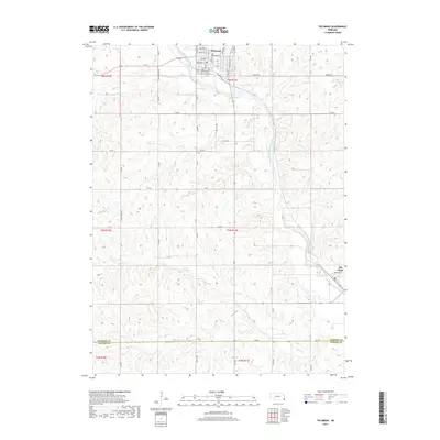
2017 Map of Tecumseh
USGS Topo · Published 2017About this map
Tecumseh serves as the primary hub of this eastern Nebraska landscape, where a grid of town streets like Broadway St and Calhoun St meets the winding course of the North Fork Big Nemaha River. The surrounding rural territory is defined by a dense network of sectional roads and watercourses, including Badger Br and Corson Br. To the southeast, the small settlement of Elk Creek is situated near the stream of the same name. The map documents the interface between the agricultural uplands and the river valley, showing the transition from the Johnson County seat to the Johnson Co Pawnee Co border in the south. Notable infrastructure includes the Spring Cr Reservoir 9-2 and named rural thoroughfares such as Maple Grove Rd, which provide context for the region's land use and local geography.
Find a feature on this map
37 named features on this map. Tap any name to fly to it.
Don’t see what you’re looking for? This feature index may not catch every label — zoom into the map to look around manually.
Map Details
Editions of this 2017 Tecumseh Map
This is the sole edition of this map. No revisions or reprints were ever made.
Other maps of this area
1955 · Lincoln
USGS Topo · 1:250,000
1957 · Lincoln
USGS Topo · 1:250,000
1958 · Lincoln
USGS Topo · 1:250,000
1965 · Burchard
USGS Topo · 1:24,000
1965 · Table Rock
USGS Topo · 1:24,000
1965 · Tecumseh
USGS Topo · 1:24,000
1965 · Steinauer
USGS Topo · 1:24,000
1965 · Tecumseh SE
USGS Topo · 1:24,000
1965 · Tecumseh NW
USGS Topo · 1:24,000
1965 · Vesta
USGS Topo · 1:24,000