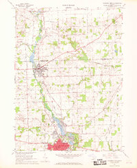
1967 Map of Tecumseh North
USGS Topo · Published 1969About this map
Tecumseh and Clinton anchor this mid-century look at the Raisin River valley, where the industrial and civic heart of southeastern Michigan is clearly defined. The Penn Central rail line cuts a northwest-southeast path through the landscape, connecting these primary settlements and skirting the edge of the River Raisin. In the southern portion of the sheet, the expansive Red Millpond and Standish Pond illustrate the local water management and industrial history tied to the river's flow. Small hamlets like Bridgewater Center and Newburg appear alongside rural landmarks such as the Assembly of God Ch and Wesley Fellowship Ch. Genealogists will find particular value in the detailed plotting of Brookside Cemetery and several Cem or Alen Cem sites, while the infrastructure of the era is marked by a Radio Tower and municipal sites like the Post Office and City Hall in downtown Tecumseh.
Find a feature on this map
50 named features on this map. Tap any name to fly to it.
Don’t see what you’re looking for? This feature index may not catch every label — zoom into the map to look around manually.
Map Details
Editions of this 1967 Tecumseh North Map
2 editions found
Other maps of this area

1904 · Ann Arbor
USGS Topo · 1:125,000

1906 · Saline
USGS Topo · 1:62,500

1908 · Ann Arbor
USGS Topo · 1:125,000

1939 · Blissfield
USGS Topo · 1:62,500

1941 · Blissfield
USGS Topo · 1:62,500

1948 · Manchester
USGS Topo · 1:62,500

1949 · Manchester
USGS Topo · 1:62,500

1953 · Fort Wayne
USGS Topo · 1:250,000

1954 · Detroit
USGS Topo · 1:250,000

1956 · Fort Wayne
USGS Topo · 1:250,000