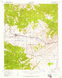
1943 Map of Tehachapi
USGS Topo · Published 1958About this map
The Tehachapi Mountains and the southern edge of the Sierra Nevada converge on this 1943 survey, centered on the high mountain pass that serves as a vital gateway between the Central Valley and the Mojave Desert. At the heart of the landscape lies Tehachapi, a rail-oriented town positioned along the Southern Pacific tracks. The infrastructure of the era is remarkably clear, showing the Los Angeles Aqueduct snaking through the south and the industrial footprint of the Cement Plant at Monolith. Notable for researchers are the numerous resource extraction points, including a Quarry, Limestone, and Dolomite deposits, which highlight the region's geological and economic significance. From the heights of Double Mountain to the seasonal waters of Proctor Lake, the map documents the critical transit and water routes that shaped Kern County's development during the war years.
Find a feature on this map
28 named features on this map. Tap any name to fly to it.
Don’t see what you’re looking for? This feature index may not catch every label — zoom into the map to look around manually.
Map Details
Editions of this 1943 Tehachapi Map
4 editions found
Other maps of this area

1903 · Tejon
USGS Topo · 1:125,000

1914 · Caliente
USGS Topo · 1:125,000

1915 · Elizabeth Lake
USGS Topo · 1:125,000

1915 · Mojave
USGS Topo · 1:125,000

1917 · Elizabeth Lake
USGS Topo · 1:125,000

1943 · Rosamond
USGS Topo · 1:62,500

1943 · Tehachapi
USGS Topo · 1:62,500

1943 · Cross Mountain
USGS Topo · 1:62,500

1943 · Emerald Mtn
USGS Topo · 1:62,500

1943 · Cummings Mountain
USGS Topo · 1:62,500