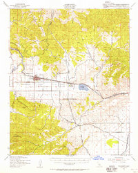
1943 Map of Tehachapi
USGS Topo · Published 1956About this map
The Southern Pacific railroad creates a high-altitude transportation corridor through the Kern County landscape, connecting the agricultural valley to the high desert. This 1943 survey documents the industrial activity concentrated around Monolith, where a Cement Plant and nearby Quarry operations utilize the mineral deposits of the Tehachapi Mountains. The city of Tehachapi serves as a central hub, flanked by specialized infrastructure including Kern County Airport No 4 and the vital Los Angeles Aqueduct cutting across the southern terrain.
Find a feature on this map
37 named features on this map. Tap any name to fly to it.
Don’t see what you’re looking for? This feature index may not catch every label — zoom into the map to look around manually.
Map Details
Editions of this 1943 Tehachapi Map
4 editions found
Other maps of this area

1903 · Tejon
USGS Topo · 1:125,000

1914 · Caliente
USGS Topo · 1:125,000

1915 · Elizabeth Lake
USGS Topo · 1:125,000

1915 · Mojave
USGS Topo · 1:125,000

1917 · Elizabeth Lake
USGS Topo · 1:125,000

1943 · Rosamond
USGS Topo · 1:62,500

1943 · Tehachapi
USGS Topo · 1:62,500

1943 · Cross Mountain
USGS Topo · 1:62,500

1943 · Emerald Mtn
USGS Topo · 1:62,500

1943 · Cummings Mountain
USGS Topo · 1:62,500