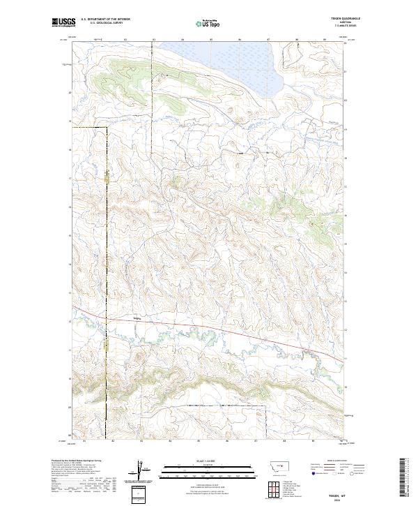
War Horse National Wildlife Refuge dominates the northern reaches of this landscape, where the prairie meets a complex system of drainage and irrigation. The settlement of Teigen is located along McDonald Creek, positioned near the boundary between Fergus and Petroleum counties. This area is defined by its water management and transit routes, with the Winnett Irrigation County Ditch cutting through the northeast and the Double S Cutoff providing a critical local connection. The terrain is marked by the winding paths of Buffalo Creek and Dry Creek, which carve through the plains. Local history is anchored by landmarks such as Cemetery Rd and Blakeslee Rd, reflecting the sparse but enduring network of ranching and rural infrastructure in this portion of central Montana.
16 named features on this map. Tap any name to fly to it.
Don’t see what you’re looking for? This feature index may not catch every label — zoom into the map to look around manually.
This is the sole edition of this map. No revisions or reprints were ever made.
68 maps found

1962 Maxwell Ranch
Petroleum County, MT

1962 Mosby
Petroleum County, MT

1963 Breed Spring
Petroleum County, MT

1963 Kelley
Petroleum County, MT

1963 Mud Spring
Petroleum County, MT

1963 Petrolia Lake
Petroleum County, MT

1965 Chain Buttes
Petroleum County, MT

1965 Dry Coulee
Petroleum County, MT

1965 Germaine Coulee West
Petroleum County, MT

1965 Weingart Place NW
Petroleum County, MT

1965 Weingart Place
Petroleum County, MT

1967 Fail Ranch
Petroleum County, MT

1971 Hanson Flat
Petroleum County, MT

1985 Brown Spring
Petroleum County, MT

1985 Davis Spring
Petroleum County, MT

1985 Dovetail Butte
Petroleum County, MT

1985 Kirkendal Flat
Petroleum County, MT

1986 Cat Creek NW
Petroleum County, MT

1986 Cat Creek
Petroleum County, MT

1986 Crowley Dam
Petroleum County, MT

1986 Dry Blood Creek East
Petroleum County, MT

1986 Dry Blood Creek West
Petroleum County, MT

1986 Flatwillow
Petroleum County, MT

1986 Ingals Dam
Petroleum County, MT

1986 Little Bear Lake
Petroleum County, MT

1986 Pike Creek Hills East
Petroleum County, MT

1986 Snoose Creek
Petroleum County, MT

1986 Teigen NW
Petroleum County, MT

1986 Teigen
Petroleum County, MT

1986 Tin Can Hill
Petroleum County, MT

1986 Wild Horse Lake
Petroleum County, MT

1986 Winnett North
Petroleum County, MT

1986 Winnett South
Petroleum County, MT

1986 Yellow Water Reservoir
Petroleum County, MT

2024 Breed Spring
Petroleum County, MT

2024 Brown Spring
Petroleum County, MT

2024 Cat Creek NW
Petroleum County, MT

2024 Cat Creek
Petroleum County, MT

2024 Chain Buttes
Petroleum County, MT

2024 Crowley Dam
Petroleum County, MT

2024 Davis Spring
Petroleum County, MT

2024 Dovetail Butte
Petroleum County, MT

2024 Dry Blood Creek East
Petroleum County, MT

2024 Dry Blood Creek West
Petroleum County, MT

2024 Dry Coulee
Petroleum County, MT

2024 Fail Ranch
Petroleum County, MT

2024 Flatwillow
Petroleum County, MT

2024 Germaine Coulee West
Petroleum County, MT

2024 Hanson Flat
Petroleum County, MT

2024 Ingals Dam
Petroleum County, MT

2024 Kelley
Petroleum County, MT

2024 Kirkendal Flat
Petroleum County, MT

2024 Little Bear Lake
Petroleum County, MT

2024 Maxwell Ranch
Petroleum County, MT

2024 Mosby
Petroleum County, MT

2024 Mud Spring
Petroleum County, MT

2024 Petrolia Lake
Petroleum County, MT

2024 Pike Creek Hills East
Petroleum County, MT

2024 Snoose Creek
Petroleum County, MT

2024 Teigen NW
Petroleum County, MT

2024 Teigen
Petroleum County, MT

2024 Tin Can Hill
Petroleum County, MT

2024 Weingart Place NW
Petroleum County, MT

2024 Weingart Place
Petroleum County, MT

2024 Wild Horse Lake
Petroleum County, MT

2024 Winnett North
Petroleum County, MT

2024 Winnett South
Petroleum County, MT

2024 Yellow Water Reservoir
Petroleum County, MT









