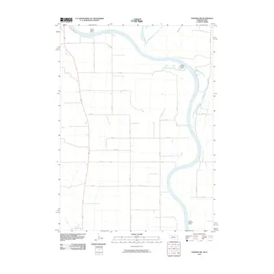
2010 Map of Tekamah NW
USGS Topo · Published 2010About this map
The Missouri River defines the eastern boundary of this landscape, its path marked by deep meanders including Lower Decatur Bend, Upper Louisville Bend, and Lower Blencoe Bend. The floodplain is crisscrossed by a network of drainage channels such as Wychoff Ditch and Riverside Ditch, illustrating the engineered nature of the alluvial plains. A grid of rural roads, including S Riverview Dr and Filbert Ave, segments the fertile bottomlands, while Cypress Ave and Elder Ave provide access to the river's edge. This 2010 survey reflects a period when modern GPS and satellite imagery data were first being integrated into topographic mapping, providing precise detail of the shifting riverbanks and the agricultural infrastructure essential to this Missouri River valley region.
Find a feature on this map
29 named features on this map. Tap any name to fly to it.
Don’t see what you’re looking for? This feature index may not catch every label — zoom into the map to look around manually.
Map Details
Editions of this 2010 Tekamah NW Map
This is the sole edition of this map. No revisions or reprints were ever made.
Other maps of this area

1955 · Sioux City
USGS Topo · 1:250,000

1955 · Fremont
USGS Topo · 1:250,000

1957 · Fremont
USGS Topo · 1:250,000

1958 · Sioux City
USGS Topo · 1:250,000

1958 · Fremont
USGS Topo · 1:250,000

1959 · Sioux City
USGS Topo · 1:250,000

1966 · Macy
USGS Topo · 1:24,000

1969 · Onawa
USGS Topo · 1:24,000
1969 · Onawa SW
USGS Topo · 1:24,000

1970 · Oakland SE
USGS Topo · 1:24,000