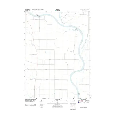
2011 Map of Tekamah NW
USGS Topo · Published 2011About this map
The Missouri River forms the defining boundary of this landscape along the Nebraska-Iowa border in 2011, characterized by its dramatic sweeping curves and engineered water management systems. Distinctive river features like Lower Decatur Bend, Upper Louisville Bend, and Lower Blencoe Bend illustrate the meandering nature of the waterway. The interior agricultural land is partitioned by a rigid grid of county roads such as Co Road V and Co Road Tu, which are punctuated by irrigation and drainage infrastructure including Wychoff Ditch and Riverside Ditch. This era of the Missouri River valley shows a highly managed flood plain where the wild path of the river is bordered by established residential and service corridors like S Riverview Dr and 3rd Ave near the community of Decatur.
Find a feature on this map
30 named features on this map. Tap any name to fly to it.
Don’t see what you’re looking for? This feature index may not catch every label — zoom into the map to look around manually.
Map Details
Editions of this 2011 Tekamah NW Map
This is the sole edition of this map. No revisions or reprints were ever made.
Other maps of this area

1955 · Sioux City
USGS Topo · 1:250,000

1955 · Fremont
USGS Topo · 1:250,000

1957 · Fremont
USGS Topo · 1:250,000

1958 · Sioux City
USGS Topo · 1:250,000

1958 · Fremont
USGS Topo · 1:250,000

1959 · Sioux City
USGS Topo · 1:250,000

1966 · Macy
USGS Topo · 1:24,000

1969 · Onawa
USGS Topo · 1:24,000
1969 · Onawa SW
USGS Topo · 1:24,000

1970 · Oakland SE
USGS Topo · 1:24,000