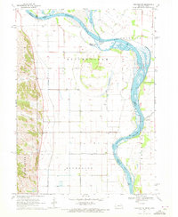
1970 Map of Tekamah NW
USGS Topo · Published 1972About this map
The Missouri River defines the shifting border between Nebraska and Iowa in this 1970 survey, carving a path through the alluvial bottomlands of Quinnebaugh and Riverside townships. The landscape is heavily modified by an intricate drainage network designed to manage the floodplain, including the Major Ditch, Wychoff Ditch, and the Combination Ditch. These engineered waterways, along with the Mc Candless Cleghorn Outlet, supported the intensive agricultural use of the fertile river valley.
Find a feature on this map
20 named features on this map. Tap any name to fly to it.
Don’t see what you’re looking for? This feature index may not catch every label — zoom into the map to look around manually.
Map Details
Editions of this 1970 Tekamah NW Map
This is the sole edition of this map. No revisions or reprints were ever made.
Other maps of this area

1955 · Sioux City
USGS Topo · 1:250,000

1955 · Fremont
USGS Topo · 1:250,000

1957 · Fremont
USGS Topo · 1:250,000

1958 · Sioux City
USGS Topo · 1:250,000

1958 · Fremont
USGS Topo · 1:250,000

1959 · Sioux City
USGS Topo · 1:250,000

1966 · Macy
USGS Topo · 1:24,000

1969 · Onawa
USGS Topo · 1:24,000
1969 · Onawa SW
USGS Topo · 1:24,000

1970 · Oakland SE
USGS Topo · 1:24,000