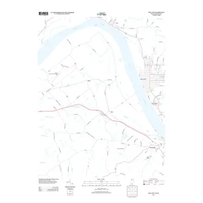
2013 Map of Tell City
USGS Topo · Published 2013About this map
The Ohio River carves a deep arc through this landscape, serving as the primary geographic border between Indiana and Kentucky. On the Indiana bank, the street grid of Tell City dominates the eastern shore, showing a dense residential and commercial pattern that transitions into the smaller riverfront community of Troy to the north. Across the water, the Kentucky side features the settlement of Hawesville and the expansive Hancock County Airport-Ron Lewis Field. The interior terrain is defined by a complex network of waterways, including the winding path of Muddy Gut and the various branches of Yellow Creek, such as N Yellow Cr Fork and S Yellow Cr Fork. This 2013 survey illustrates the continued importance of river-adjacent infrastructure, from the small airstrips like Lamar Field Airport to the established road networks connecting rural hamlets like Adair and Petri.
Find a feature on this map
102 named features on this map. Tap any name to fly to it.
Don’t see what you’re looking for? This feature index may not catch every label — zoom into the map to look around manually.
Map Details
Editions of this 2013 Tell City Map
This is the sole edition of this map. No revisions or reprints were ever made.
Other maps of this area

1900 · St Meinrad
USGS Topo · 1:62,500

1903 · St. Meinrad
USGS Topo · 1:62,500

1903 · Tell City
USGS Topo · 1:62,500

1934 · Cannelton
USGS Topo · 1:62,500

1949 · Cannelton
USGS Topo · 1:24,000

1953 · Cannelton
USGS Topo · 1:24,000

1953 · Lewisport
USGS Topo · 1:24,000

1953 · Cloverport
USGS Topo · 1:24,000

1953 · Tell City
USGS Topo · 1:24,000
1953 · Maceo
USGS Topo · 1:24,000