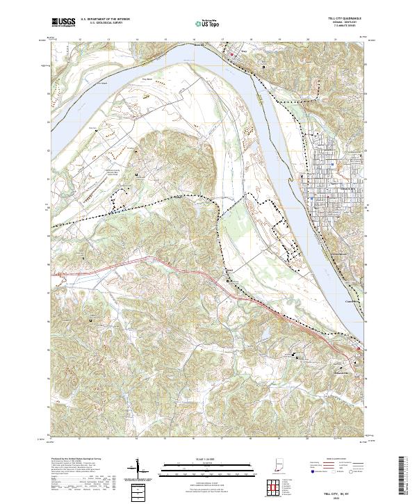
2022 Map of Tell City
USGS Topo · Published 2022About this map
The Ohio River carves a dramatic path between Indiana and Kentucky, defining the lives and geography of the riverfront communities of Tell City, Cannelton, and Hawesville. This landscape is deeply rooted in local lineage, evidenced by a dense network of family and parish burial grounds such as the Beauchamp Family Cem, Saint Paul Cem, and Greathouse Cem. The terrain transitions from the river flats near Troy Bend and Corn Island to the higher elevations of Troy Ridge Rd.
Find a feature on this map
109 named features on this map. Tap any name to fly to it.
Don’t see what you’re looking for? This feature index may not catch every label — zoom into the map to look around manually.
Map Details
Editions of this 2022 Tell City Map
This is the sole edition of this map. No revisions or reprints were ever made.
Other maps of this area

1900 · St Meinrad
USGS Topo · 1:62,500

1903 · St. Meinrad
USGS Topo · 1:62,500

1903 · Tell City
USGS Topo · 1:62,500

1934 · Cannelton
USGS Topo · 1:62,500

1949 · Cannelton
USGS Topo · 1:24,000

1953 · Cannelton
USGS Topo · 1:24,000

1953 · Lewisport
USGS Topo · 1:24,000

1953 · Cloverport
USGS Topo · 1:24,000

1953 · Tell City
USGS Topo · 1:24,000
1953 · Maceo
USGS Topo · 1:24,000