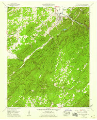
1957 Map of Tellico Plains
USGS Topo · Published 1959About this map
Tellico Plains serves as the focal point for this survey, situated where the Tellico River and Tellico Lake meet the steep rise of the Unicoi Mtns. The mapping reflects a mountain economy transitioning between agriculture and timber within the Cherokee National Forest. To the southwest, Rural Vale and its Conasauga Mill on the Conasauga Creek illustrate the era's small-scale water-powered industry, while the Louisville & Nashville RR corridor indicates the town's role as a logistical hub for the surrounding ridges.
Find a feature on this map
95 named features on this map. Tap any name to fly to it.
Don’t see what you’re looking for? This feature index may not catch every label — zoom into the map to look around manually.
Map Details
Editions of this 1957 Tellico Plains Map
3 editions found
Other maps of this area

1893 · Murphy
USGS Topo · 1:125,000

1914 · Murphy
USGS Topo · 1:125,000

1933 · Haw Knob
USGS Topo · 1:48,000

1933 · Bald River Falls
USGS Topo · 1:24,000

1933 · Rafter
USGS Topo · 1:24,000

1934 · Mount Vernon
USGS Topo · 1:24,000

1934 · Mecca
USGS Topo · 1:24,000

1934 · Unaka
USGS Topo · 1:24,000

1934 · Englewood
USGS Topo · 1:24,000

1934 · Murphy
USGS Topo · 1:48,000