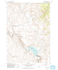
1993 Map of Telocaset
USGS Topo · Published 1993About this map
Telocaset stands as the central settlement in this corner of the state, situated along the base of Telocaset Hill where the high desert terrain meets the eastern slopes. The landscape is defined by the significant hydrological engineering of the Thief Valley Reservoir, held by the Thief Valley Dam at the confluence of the Powder River and Cusick Creek. This 1993 revision, based on photographs dating back to 1963, shows a region defined by a mix of agriculture in the Antelope Valley and the wilder, wooded reaches of the Whitman National Forest to the northeast. Scattered mining activity is evident through several Prospects and a Quarry near Antelope Creek, while family-named landmarks like Prescott Gulch and Gentry Creek suggest the long-standing ranching and settlement history of the Union and Baker County line.
Find a feature on this map
31 named features on this map. Tap any name to fly to it.
Don’t see what you’re looking for? This feature index may not catch every label — zoom into the map to look around manually.
Map Details
Editions of this 1993 Telocaset Map
This is the sole edition of this map. No revisions or reprints were ever made.
Other maps of this area

1901 · Baker City
USGS Topo · 1:125,000

1906 · Telocaset
USGS Topo · 1:125,000

1955 · Baker
USGS Topo · 1:250,000

1955 · Grangeville
USGS Topo · 1:250,000

1959 · Baker
USGS Topo · 1:250,000

1959 · Grangeville
USGS Topo · 1:250,000

1965 · Union
USGS Topo · 1:24,000

1965 · Medical Springs
USGS Topo · 1:24,000
1965 · North Powder
USGS Topo · 1:24,000

1965 · Little Catherine Creek
USGS Topo · 1:24,000