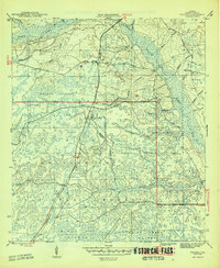
1946 Map of Telogia
USGS Topo · Published 1946About this map
Telogia serves as the primary settlement in this corner of Liberty County, situated along the line of the Apalachicola Northern railroad. The landscape is defined by the dense hydrological network of the Apalachicola National Forest, where numerous named watercourses like Telogia Creek, Reedy Branch, and Western Branch drain into larger swamps and basins. Notable family landmarks and early rural infrastructure are visible across the terrain, including Old Burnoff Cem, Evans Cem, and the strategically placed Mercer Fire Tower.
Find a feature on this map
36 named features on this map. Tap any name to fly to it.
Don’t see what you’re looking for? This feature index may not catch every label — zoom into the map to look around manually.
Map Details
Editions of this 1946 Telogia Map
2 editions found
Other maps of this area

1943 · Lake Talquin
USGS Topo · 1:62,500

1944 · Queens Bay
USGS Topo · 1:24,000

1945 · Smith Creek
USGS Topo · 1:31,680

1945 · Hosford
USGS Topo · 1:31,680

1945 · Bristol
USGS Topo · 1:31,680

1945 · Woods
USGS Topo · 1:31,680

1945 · Telogia
USGS Topo · 1:24,000

1946 · Queens Bay
USGS Topo · 1:31,680

1946 · Telogia
USGS Topo · 1:31,680
1946 · Wilma
USGS Topo · 1:31,680