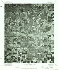
1971 Map of Tempe
USGS Topo · Published 1973About this map
Tempe and the surrounding East Valley are captured during a period of rapid suburbanization in this orthophotoquad. The imagery, derived from 1971 aerial photography, reveals the stark contrast between the traditional agricultural grid and the burgeoning residential subdivisions expanding toward Scottsdale and eastern Phoenix. Central to the landscape is the Salt River, which cuts across the quadrangle as a broad, dry bed, flanked by industrial sites and the evolving infrastructure of a growing desert metropolis. This specialized map provides researchers with a photographic record of land use before the density of the late 20th century, showing exactly where citrus groves and fields were being replaced by the neighborhood footprints that define the modern landscape of Maricopa County.
Find a feature on this map
4 named features on this map. Tap any name to fly to it.
Don’t see what you’re looking for? This feature index may not catch every label — zoom into the map to look around manually.
Map Details
Editions of this 1971 Tempe Map
This is the sole edition of this map. No revisions or reprints were ever made.
Other maps of this area

1904 · Camelback
USGS Topo · 1:62,500

1906 · Camelsback
USGS Topo · 1:62,500

1912 · Phoenix
USGS Topo · 1:62,500

1913 · Mesa
USGS Topo · 1:62,500

1914 · Phoenix
USGS Topo · 1:62,500

1915 · Mesa
USGS Topo · 1:62,500

1930 · Cave Creek
USGS Topo · 1:125,000

1939 · Cave Creek
USGS Topo · 1:125,000

1952 · Tempe
USGS Topo · 1:24,000

1952 · Chandler
USGS Topo · 1:24,000