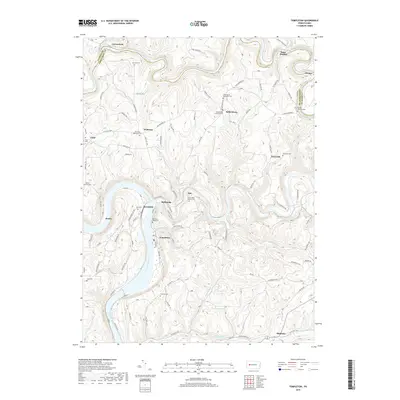
2019 Map of Templeton
USGS Topo · Published 2019About this map
The Allegheny River and Mahoning Creek carve through the dissected plateau at the border of Clarion and Armstrong Counties. This landscape is defined by its deep river valleys and the scattered upland settlements that historically supported the region's industry and agriculture. Notable for genealogists, the map identifies numerous small cemeteries tied to local churches and former industry sites, such as the Stewardson Furnace Cem near the bend of Mahoning Creek. Larger settlements like Templeton and Mahoning sit along the riverbanks, while smaller communities like Kellersburg and Widnoon occupy the high ground between drainages. The northern border follows the winding path of Redbank Creek, where Lawsonham and Saint Charles are situated. This modern survey provides a clear view of the complex road network, including Olean Rd and Kellersburg Rd, which connects these disparate hilltop and valley floor locales.
Find a feature on this map
118 named features on this map. Tap any name to fly to it.
Don’t see what you’re looking for? This feature index may not catch every label — zoom into the map to look around manually.
Map Details
Editions of this 2019 Templeton Map
This is the sole edition of this map. No revisions or reprints were ever made.
Other maps of this area

1900 · Kittanning
USGS Topo · 1:62,500

1901 · Rural Valley
USGS Topo · 1:62,500

1902 · Kittanning
USGS Topo · 1:62,500

1903 · Rural Valley
USGS Topo · 1:62,500

1906 · Clarion
USGS Topo · 1:62,500

1907 · Clarion
USGS Topo · 1:62,500

1907 · Foxburg
USGS Topo · 1:62,500

1908 · Foxburg
USGS Topo · 1:62,500

1953 · Pittsburgh
USGS Topo · 1:250,000

1954 · Pittsburgh
USGS Topo · 1:250,000