
Loading...
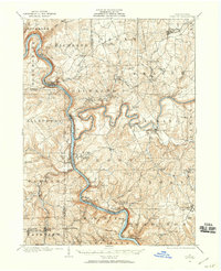
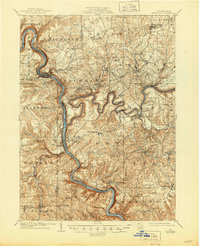
Loading map...1907 Map of Foxburg
USGS Topo · Published 1953About this map
The Allegheny River and Clarion River carve deep, winding paths through this Western Pennsylvania landscape, their confluence serving as a focal point for early twentieth-century industry and settlement. Industrial activity is evident in the numerous riverside works, including the Sarah Furnace and Canoe Furnace, alongside resource extraction at the Eagle Mine. Regional transportation is anchored by the Baltimore and Ohio and Pennsylvania railroads, which track the riverbanks to serve bustling river towns like Emlenton and Parker City.
Find a feature on this map
93 named features on this map. Tap any name to fly to it.
Don’t see what you’re looking for? This feature index may not catch every label — zoom into the map to look around manually.
Map Details
Date Portrayed1907
Date Published1953
PublisherU.S. Geological Survey
Map TypeTopographic
Scale1:62,500
Physical Dimensions17 x 20.9 inches
Editions of this 1907 Foxburg Map
2 editions found
Historical Maps of Monroe Through Time
Featured Locations
Source Details
SourceU.S. Geological Survey
CopyrightPublic Domain