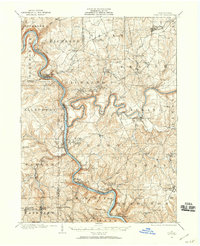
1907 Map of Foxburg
USGS Topo · Published 1959About this map
The Allegheny River carves a deep, winding course through this early 20th-century landscape, serving as the primary corridor for commerce and transport between Venango, Clarion, Butler, and Armstrong counties. The river's influence is evident in the concentration of settlements and industry along its banks, from the borough of Emlenton in the north to Parker City and West Monterey PO downstream. Industrial activity is prominent, marked by the Blue Goose Mine and Eagle Mine near the river, while the ruins of the Canoe Furnace suggest the region's earlier iron-making heritage.
Find a feature on this map
91 named features on this map. Tap any name to fly to it.
Don’t see what you’re looking for? This feature index may not catch every label — zoom into the map to look around manually.
Map Details
Editions of this 1907 Foxburg Map
2 editions found
Other maps of this area

1900 · Kittanning
USGS Topo · 1:62,500

1901 · Rural Valley
USGS Topo · 1:62,500

1902 · Kittanning
USGS Topo · 1:62,500

1903 · Rural Valley
USGS Topo · 1:62,500

1906 · Clarion
USGS Topo · 1:62,500

1907 · Clarion
USGS Topo · 1:62,500

1907 · Foxburg
USGS Topo · 1:62,500

1908 · Foxburg
USGS Topo · 1:62,500

1909 · Franklin
USGS Topo · 1:62,500

1909 · Butler
USGS Topo · 1:62,500