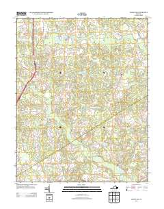
2013 Map of Templeton
USGS Topo · Published 2013About this map
Warwick Swamp and a network of named wetlands dominate this Prince George County landscape, illustrating the intricate drainage patterns of the Virginia coastal plain. The settlement of Templeton serves as a central junction where Prince George Dr and Courtland Rd converge. Historical industry is evidenced by the presence of Lees Millpond and Lees Mill to the north, as well as Belsches Millpond and Belsches Mill Swamp in the southern reaches. These features, alongside Johnsons Pond and Couches Pond, suggest a history of water-dependent local enterprise. The map also captures modern land use, from the residential layout of Sunny- Brook Farms to the remnant Railroad Bed Rd, providing a clear view of how transportation and natural hydrology have shaped this rural corridor.
Find a feature on this map
65 named features on this map. Tap any name to fly to it.
Don’t see what you’re looking for? This feature index may not catch every label — zoom into the map to look around manually.
Map Details
Editions of this 2013 Templeton Map
This is the sole edition of this map. No revisions or reprints were ever made.
Other maps of this area

1894 · Petersburg
USGS Topo · 1:62,500

1919 · Jarratt
USGS Topo · 1:62,500

1919 · Disputanta
USGS Topo · 1:62,500

1919 · Homeville
USGS Topo · 1:48,000

1920 · Homeville
USGS Topo · 1:62,500

1943 · Littleton
USGS Topo · 1:31,680

1943 · Disputanta
USGS Topo · 1:31,680

1943 · Richmond
USGS Topo · 1:250,000

1944 · Reams
USGS Topo · 1:31,680
1944 · Petersburg
USGS Topo · 1:31,680