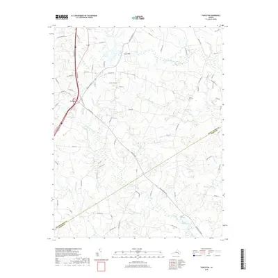
2019 Map of Templeton
USGS Topo · Published 2019About this map
Lees Mill and the crossroads of Templeton anchor this landscape along the border of Prince George and Sussex counties. The terrain is defined by an intricate network of waterways, including the winding Warwick Swamp and Joseph Swamp, which converge in a region historically shaped by timber and milling. The presence of Belsches Millpond and Belsches Mill Swamp indicates the enduring legacy of early water-powered industry in rural Virginia. For genealogists and local historians, several landmarks offer points of connection to the past, such as Loving Union Cem and Little Mount Cem. The map also traces modern infrastructure alongside vestiges of older transportation routes, most notably Railroad Bed Rd, suggesting a landscape in transition where old rail corridors have been repurposed for contemporary access.
Find a feature on this map
75 named features on this map. Tap any name to fly to it.
Don’t see what you’re looking for? This feature index may not catch every label — zoom into the map to look around manually.
Map Details
Editions of this 2019 Templeton Map
This is the sole edition of this map. No revisions or reprints were ever made.
Other maps of this area

1894 · Petersburg
USGS Topo · 1:62,500

1919 · Jarratt
USGS Topo · 1:62,500

1919 · Disputanta
USGS Topo · 1:62,500

1919 · Homeville
USGS Topo · 1:48,000

1920 · Homeville
USGS Topo · 1:62,500

1943 · Littleton
USGS Topo · 1:31,680

1943 · Disputanta
USGS Topo · 1:31,680

1943 · Richmond
USGS Topo · 1:250,000

1944 · Reams
USGS Topo · 1:31,680
1944 · Petersburg
USGS Topo · 1:31,680