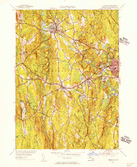
1954 Map of Templeton
USGS Topo · Published 1956About this map
Baldwinsville and East Templeton anchor this mid-century portrait of Worcester County, where the industrial and institutional character of the land is clearly defined. The Boston and Maine and Central Vermont railroads intersect near Otter River, tracing the valley floor and connecting the village centers. The northern portion of the map is dominated by the Otter River State Forest and the extensive grounds of the Fernald State Sch, reflecting a landscape heavily influenced by state management and public institutions.
Find a feature on this map
52 named features on this map. Tap any name to fly to it.
Don’t see what you’re looking for? This feature index may not catch every label — zoom into the map to look around manually.
Map Details
Editions of this 1954 Templeton Map
3 editions found
Other maps of this area

1885 · Worcester
USGS Topo · 1:62,500

1886 · Worcester
USGS Topo · 1:62,500

1887 · Winchendon
USGS Topo · 1:62,500

1887 · Barre
USGS Topo · 1:62,500

1887 · Fitchburg
USGS Topo · 1:62,500

1889 · Fitchburg
USGS Topo · 1:62,500

1889 · Barre
USGS Topo · 1:62,500

1890 · Winchendon
USGS Topo · 1:62,500

1892 · Worcester
USGS Topo · 1:62,500

1893 · Fitchburg
USGS Topo · 1:62,500