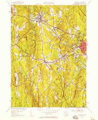
1954 Map of Templeton
USGS Topo · Published 1958About this map
The Otter River flows through a landscape of heavy industrial and institutional presence in mid-century Worcester County. The Boston and Maine Railroad serves as the primary corridor for commerce, passing through the village of Baldwinsville and connecting to the Templeton Sta. To the north, the Fernald State Sch occupies a significant tract near Elliott Hill, while the southeastern corner shows the growing outskirts of Gardner and the Gardner Landing Field. Much of the terrain is defined by an extensive network of managed timberlands, including the Otter River State Forest and Templeton State Forest. Smaller settlements like Brooks Village and Goulding Village are shown with their original building footprints, offering genealogists a clear view of local infrastructure alongside ಹಲವಾರು historical burying grounds such as Pine Grove Cem and Greenlawn Cem.
Find a feature on this map
61 named features on this map. Tap any name to fly to it.
Don’t see what you’re looking for? This feature index may not catch every label — zoom into the map to look around manually.
Map Details
Editions of this 1954 Templeton Map
3 editions found
Other maps of this area

1885 · Worcester
USGS Topo · 1:62,500

1886 · Worcester
USGS Topo · 1:62,500

1887 · Winchendon
USGS Topo · 1:62,500

1887 · Barre
USGS Topo · 1:62,500

1887 · Fitchburg
USGS Topo · 1:62,500

1889 · Fitchburg
USGS Topo · 1:62,500

1889 · Barre
USGS Topo · 1:62,500

1890 · Winchendon
USGS Topo · 1:62,500

1892 · Worcester
USGS Topo · 1:62,500

1893 · Fitchburg
USGS Topo · 1:62,500