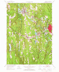
1954 Map of Templeton
USGS Topo · Published 1966About this map
The Otter River valley defines this mid-century portrait of Worcester County, where industrial villages like Baldwinville and East Templeton developed along the water's power and the path of the Boston and Maine Railroad. The landscape is a mix of dense woodlands, including the Templeton State Forest and Birch Hill State Forest, and concentrated civic centers. Of particular note for local historians is the site of the Fernald State Sch and the Gardner Landing Field near the eastern edge. Local infrastructure is highly detailed, showing everything from the Drive-in Theatre near Gardner to cemeteries like Wildwood Cem. The map captures the transition of smaller hamlets such as Brooks Village and Goulding Village as they maintained their identities within the larger township during the post-war era.
Find a feature on this map
82 named features on this map. Tap any name to fly to it.
Don’t see what you’re looking for? This feature index may not catch every label — zoom into the map to look around manually.
Map Details
Editions of this 1954 Templeton Map
3 editions found
Other maps of this area

1885 · Worcester
USGS Topo · 1:62,500

1886 · Worcester
USGS Topo · 1:62,500

1887 · Winchendon
USGS Topo · 1:62,500

1887 · Barre
USGS Topo · 1:62,500

1887 · Fitchburg
USGS Topo · 1:62,500

1889 · Fitchburg
USGS Topo · 1:62,500

1889 · Barre
USGS Topo · 1:62,500

1890 · Winchendon
USGS Topo · 1:62,500

1892 · Worcester
USGS Topo · 1:62,500

1893 · Fitchburg
USGS Topo · 1:62,500