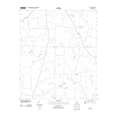
2011 Map of Tempy
USGS Topo · Published 2011About this map
The community of Tempy serves as a central point in this rural Georgia landscape, characterized by a network of small creeks and farm-related water features. Numerous family and community burial grounds, such as New Bethel Cemetery, Willis Cemetery, and Thornhill Cemetery, are scattered throughout the quadrangle, offering significant touchpoints for genealogical research. The land is drained by a complex system of waterways, including Horse Creek, Warrior Creek, and Okapilco Creek, many of which have been dammed to create local reservoirs like Lumkins Lake and Shingle Farm Service Lake.
Find a feature on this map
62 named features on this map. Tap any name to fly to it.
Don’t see what you’re looking for? This feature index may not catch every label — zoom into the map to look around manually.
Map Details
Editions of this 2011 Tempy Map
This is the sole edition of this map. No revisions or reprints were ever made.
Other maps of this area

1953 · Waycross
USGS Topo · 1:250,000

1956 · Sylvester
USGS Topo · 1:62,500

1956 · Doerun
USGS Topo · 1:62,500

1958 · Waycross
USGS Topo · 1:250,000

1973 · Sumner
USGS Topo · 1:24,000

1973 · Ty Ty
USGS Topo · 1:24,000

1973 · Norman Park
USGS Topo · 1:24,000
1973 · Acree
USGS Topo · 1:24,000

1973 · Sylvester
USGS Topo · 1:24,000
1974 · Doerun
USGS Topo · 1:24,000