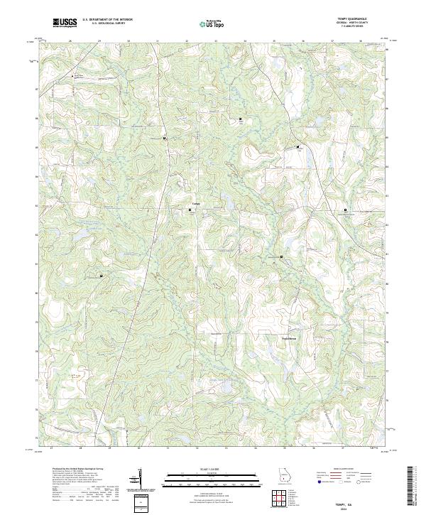
2024 Map of Tempy
USGS Topo · Published 2024About this map
Tempy and Powelltown serve as the primary landmarks in this rural Worth County landscape, which is defined by an intricate network of tributaries feeding the Little Ochlockonee River. The area's genealogical depth is evident in the numerous family and community burial grounds scattered throughout, such as Tempy Cem, Thornhill Cem, and Willis Cem. The terrain is shaped by a high density of small water bodies, including Strickland Lake and Sizemore Lake, along with named drainages like Warrior Creek and Horse Creek. These waterways and their surrounding wetlands reflect a long-standing agricultural and timber-based land use pattern. The road network, comprising routes like Oak Grove Rd and P T Salter Rd, connects isolated homesteads and historical church sites such as New Bethel Baptist Church Cem, providing a detailed look at the rural infrastructure of South Georgia in the modern era.
Find a feature on this map
65 named features on this map. Tap any name to fly to it.
Don’t see what you’re looking for? This feature index may not catch every label — zoom into the map to look around manually.
Map Details
Editions of this 2024 Tempy Map
This is the sole edition of this map. No revisions or reprints were ever made.
Other maps of this area

1953 · Waycross
USGS Topo · 1:250,000

1956 · Sylvester
USGS Topo · 1:62,500

1956 · Doerun
USGS Topo · 1:62,500

1958 · Waycross
USGS Topo · 1:250,000

1973 · Sumner
USGS Topo · 1:24,000

1973 · Ty Ty
USGS Topo · 1:24,000

1973 · Norman Park
USGS Topo · 1:24,000
1973 · Acree
USGS Topo · 1:24,000

1973 · Sylvester
USGS Topo · 1:24,000
1974 · Doerun
USGS Topo · 1:24,000