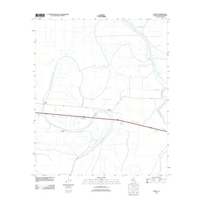
2012 Map of Tendal
USGS Topo · Published 2012About this map
The Tensas River carves a winding path through the low-lying Madison Parish landscape, defining the character of this rural agricultural region. Small settlements like Quebec and Tendal anchor the map near the central transport corridor, while the surrounding territory is intricately carved by seasonal waterways such as Island Chute, Bayou Despair, and Tensas Bayou. The presence of Eldorado Plantation Rd and Charles Brown Rd points to the area's deep-rooted agrarian history and family-held lands. Aviation interest is noted by the 4B Ranch Airport, positioned south of the main road. The drainage patterns of the Judd Bayou and Mothligam Bayou reveal the flat, alluvial nature of the Mississippi Delta country, where water management and road placement are dictate by the subtle shifts in elevation along the river bends.
Find a feature on this map
15 named features on this map. Tap any name to fly to it.
Don’t see what you’re looking for? This feature index may not catch every label — zoom into the map to look around manually.
Map Details
Editions of this 2012 Tendal Map
This is the sole edition of this map. No revisions or reprints were ever made.
Other maps of this area

1909 · Tallulah
USGS Topo · 1:24,000

1935 · Waverly
USGS Topo · 1:62,500

1939 · Talla Bena
USGS Topo · 1:62,500

1939 · Alsatia
USGS Topo · 1:62,500

1955 · Jackson
USGS Topo · 1:250,000

1959 · Mitchiner
USGS Topo · 1:62,500

1961 · Jackson
USGS Topo · 1:250,000

1961 · Waverly
USGS Topo · 1:62,500

1962 · Jackson
USGS Topo · 1:250,000
1963 · Fortune Fork
USGS Topo · 1:24,000