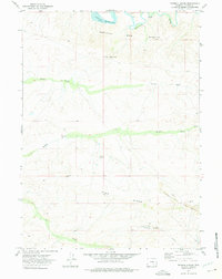
1971 Map of Tenmile Spring
USGS Topo · Published 1975About this map
Vanguard Mine No. 1 and an extensive network of Strip Mines dominate the southern landscape of this Carbon County quadrangle, where industrial operations define the high desert terrain. The map records a complex mining infrastructure connected by a large Conveyor system moving material across the slopes of Sand Ridge. In the northern section, the Medicine Bow River flows toward the Seminoe Reservoir, its course framed by the sharp elevation changes of the Medicine Bow Breaks. Human water management is evident through a series of long-distance irrigation features, including North Ditch, Middle Ditch, and Bill Ditch, which traverse the arid basins between Brooks Knob and Tenmile Hill. From the isolated Wrights Cabin to the central Tenmile Spring, the map illustrates a landscape of resource extraction and strategic water diversion during the early 1970s.
Find a feature on this map
19 named features on this map. Tap any name to fly to it.
Don’t see what you’re looking for? This feature index may not catch every label — zoom into the map to look around manually.
Map Details
Editions of this 1971 Tenmile Spring Map
2 editions found
Other maps of this area

1893 · Fort Steele
USGS Topo · 1:125,000

1914 · Hanna
USGS Topo · 1:62,500

1914 · Walcott
USGS Topo · 1:62,500

1953 · Seminoe Dam SE
USGS Topo · 1:24,000

1953 · Schneider Ridge
USGS Topo · 1:24,000

1953 · T E Ranch
USGS Topo · 1:24,000

1954 · Rawlins
USGS Topo · 1:250,000

1955 · Casper
USGS Topo · 1:250,000

1958 · Rawlins
USGS Topo · 1:250,000

1958 · Casper
USGS Topo · 1:250,000