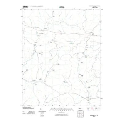
2010 Map of Tennessee City
USGS Topo · Published 2010About this map
Tennessee City Cemetery sits at the heart of a landscape defined by deeply etched drainage patterns and family-named hollows in Dickson County. This 2010 survey illustrates the complex topography surrounding Hurricane Creek and its many tributaries, including Yellow Bank Branch and Little Hurricane Creek. The region is notably rich in small family burial grounds, such as the Gray Cemetery, Washburn Cemetery, and Berryman Cemetery, which often serve as the primary markers of earlier rural settlement patterns. In the eastern reaches, the terrain levels slightly near Simmons Lake and Burch Lake, both of which are managed by significant earthworks like the Simmons Lake Dam. Between the high point of Balding Knob and the various branches, a network of country roads like Jason Chapel Rd and Garners Creek Rd connects these scattered landmarks, reflecting the persistent rural character of the Tennessee interior.
Find a feature on this map
94 named features on this map. Tap any name to fly to it.
Don’t see what you’re looking for? This feature index may not catch every label — zoom into the map to look around manually.
Map Details
Editions of this 2010 Tennessee City Map
This is the sole edition of this map. No revisions or reprints were ever made.
Other maps of this area

1901 · Colombia
USGS Topo · 1:125,000

1936 · Gorman
USGS Topo · 1:24,000

1936 · Woolworth
USGS Topo · 1:24,000

1936 · Ruskin
USGS Topo · 1:24,000

1936 · Bucksnort
USGS Topo · 1:24,000

1936 · Texas Hollow
USGS Topo · 1:24,000

1936 · Spot
USGS Topo · 1:24,000

1936 · Tennessee City
USGS Topo · 1:24,000

1936 · Dickson
USGS Topo · 1:24,000
1952 · Bucksnort
USGS Topo · 1:24,000