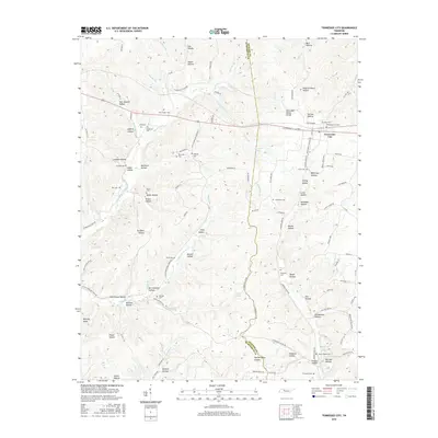
2016 Map of Tennessee City
USGS Topo · Published 2016About this map
Tennessee City sits along the northern edge of this map, positioned near the Tennessee Valley Divide where the landscape transitions into a series of deep hollows. The terrain is defined by a dense network of creek branches, including Hurricane Creek and Little Hurricane Creek, which have carved out family-named landmarks like Heath Hollow, Brown Hollow, and Murrell Hollow. This area along the Dickson and Humphreys county line preserves a high density of small family and community burial grounds. Genealogists will find numerous sites of interest, from the Tennessee City Cemetery and Rice Cemetery to more remote locations such as Washburn Cemetery, Holland Cemetery, and the Fews Chapel Cemetery located near Old Sam Hollow. The distribution of these sites suggests a long-standing pattern of rural settlement clustered around the numerous water sources like Indian Creek and Garner Creek.
Find a feature on this map
120 named features on this map. Tap any name to fly to it.
Don’t see what you’re looking for? This feature index may not catch every label — zoom into the map to look around manually.
Map Details
Editions of this 2016 Tennessee City Map
This is the sole edition of this map. No revisions or reprints were ever made.
Other maps of this area

1901 · Colombia
USGS Topo · 1:125,000

1936 · Gorman
USGS Topo · 1:24,000

1936 · Woolworth
USGS Topo · 1:24,000

1936 · Ruskin
USGS Topo · 1:24,000

1936 · Bucksnort
USGS Topo · 1:24,000

1936 · Texas Hollow
USGS Topo · 1:24,000

1936 · Spot
USGS Topo · 1:24,000

1936 · Tennessee City
USGS Topo · 1:24,000

1936 · Dickson
USGS Topo · 1:24,000
1952 · Bucksnort
USGS Topo · 1:24,000