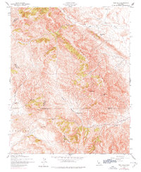
1942 Map of Tent Hills
USGS Topo · Published 1977About this map
Avenal Ridge and the Tent Hills dominate this interior California landscape, where the borders of Monterey, Kings, Kern, and San Luis Obispo counties converge. Recorded during the war years of the early 1940s, the terrain reveals a sparse network of ranching outposts such as Iron Spring Ranch, Fahey Ranch, and Acebedo Ranch. These isolated settlements are connected by unimproved dirt tracks through deep cuts like Catskin Canyon and Stoker Canyon. The geography is defined by prominent high points including Johnson Peak and Three Peaks, overlooking the broad expanse of Sunflower Valley to the northeast. Notable transit points like Cottonwood Pass and the landmark Blue Point provide evidence of historical movement through the steep ridges of the Cholame region before modern road development.
Find a feature on this map
26 named features on this map. Tap any name to fly to it.
Don’t see what you’re looking for? This feature index may not catch every label — zoom into the map to look around manually.
Map Details
Editions of this 1942 Tent Hills Map
2 editions found
Other maps of this area

1914 · Cholame
USGS Topo · 1:125,000

1915 · Cholame
USGS Topo · 1:125,000

1917 · Cholame
USGS Topo · 1:125,000

1930 · Kettleman Plain
USGS Topo · 1:31,680

1933 · Kettleman Plain
USGS Topo · 1:31,680

1934 · The Dark Hole
USGS Topo · 1:31,680

1934 · Reef Ridge
USGS Topo · 1:31,680
1937 · Reef Ridge
USGS Topo · 1:31,680
1937 · The Dark Hole
USGS Topo · 1:31,680

1942 · Tent Hills
USGS Topo · 1:24,000