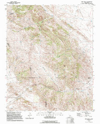
1994 Map of Tent Hills
USGS Topo · Published 1994About this map
The high ridges and deep canyons of the Avenal Ridge and the Tent Hills define this landscape along the borders of Kings, Monterey, and San Luis Obispo counties. In the early 1990s, this area remained largely undeveloped, characterized by cattle ranching and infrastructure such as numerous pipelines and water tanks. The complex topography is punctuated by prominent landmarks like Johnson Peak and the Three Peaks, while Sunflower Valley provides a level break in the northeast corner. Cultural indicators are sparse but significant, including a remote Cem near Cottonwood Creek and the notable Cottonwood Pass crossing. The presence of several named springs and 4WD tracks suggests a landscape managed for grazing and resource extraction, with the Cholame area marking the southern transition into the hills of San Luis Obispo County.
Find a feature on this map
30 named features on this map. Tap any name to fly to it.
Don’t see what you’re looking for? This feature index may not catch every label — zoom into the map to look around manually.
Map Details
Editions of this 1994 Tent Hills Map
2 editions found
Other maps of this area

1914 · Cholame
USGS Topo · 1:125,000

1915 · Cholame
USGS Topo · 1:125,000

1917 · Cholame
USGS Topo · 1:125,000

1930 · Kettleman Plain
USGS Topo · 1:31,680

1933 · Kettleman Plain
USGS Topo · 1:31,680

1934 · The Dark Hole
USGS Topo · 1:31,680

1934 · Reef Ridge
USGS Topo · 1:31,680
1937 · Reef Ridge
USGS Topo · 1:31,680
1937 · The Dark Hole
USGS Topo · 1:31,680

1942 · Tent Hills
USGS Topo · 1:24,000