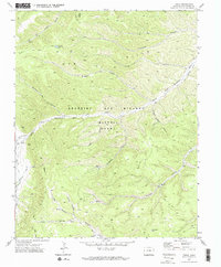
1971 Map of Tercio
USGS Topo · Published 1974About this map
Industrial extraction and mountain hydrology define this corner of Las Animas County, where the Tercio Mine and Vega Mine sit near the settlement of Tercio. The landscape is dominated by the steep drainages of the Ute Hills and the winding course of the South Fork Purgatoire River, which receives water from numerous seasonal sources like Cuatro Creek and Alamosa. A notable historical element is the presence of the Old Railroad Grade, which once served the local mining operations by following the river valley through the Beaublen and Miranda and Maxwell Grant lands. The map details a network of canyons, including Bandarito Canyon and Gallegos Canyon, alongside high-elevation features like Bingham Lake and Dead Horse Lake, reflecting a region shaped by both its geology and its turn-of-the-century mining legacy.
Find a feature on this map
30 named features on this map. Tap any name to fly to it.
Don’t see what you’re looking for? This feature index may not catch every label — zoom into the map to look around manually.
Map Details
Editions of this 1971 Tercio Map
3 editions found
Other maps of this area

1891 · Spanish Peaks
USGS Topo · 1:125,000

1893 · Spanish Peaks
USGS Topo · 1:125,000

1895 · Spanish Peaks
USGS Topo · 1:125,000

1897 · Spanish Peaks
USGS Topo · 1:125,000

1900 · Spanish Peaks
USGS Topo · 1:125,000

1954 · Raton
USGS Topo · 1:250,000

1954 · Trinidad
USGS Topo · 1:250,000

1955 · Trinidad
USGS Topo · 1:250,000

1958 · Raton
USGS Topo · 1:250,000

1958 · Trinidad
USGS Topo · 1:250,000