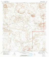
1971 Map of Terlingua
USGS Topo · Published 1973About this map
Terlingua and the neighboring mercury mining settlement at Study Butte stand as the primary anchors in this arid landscape, documented just as modern recreational interest began to redefine the region. The map reveals the intricate geography of the Chihuahuan Desert, where the perennial Terlingua Creek carves a path through high-relief terrain including Sawmill Mountain and the Rattlesnake Mountains. Evidence of the area's industrial past is visible in the numerous Mines and an Aerial Tramway near the base of Maverick Mountain, alongside various scattered Ruins that mark earlier habitations. A significant portion of the southeastern quadrant is dedicated to Big Bend National Park, highlighting the early boundaries of this protected wilderness. Water sources, vital in this climate, are meticulously noted, from Joe Black Spring to Cigar Spring, illustrating how local topography dictated the locations of early outposts and the Terlingua Landing Strip.
Find a feature on this map
47 named features on this map. Tap any name to fly to it.
Don’t see what you’re looking for? This feature index may not catch every label — zoom into the map to look around manually.
Map Details
Editions of this 1971 Terlingua Map
3 editions found
Other maps of this area

1903 · Chisos Mountains
USGS Topo · 1:125,000

1903 · Terlingua
USGS Topo · 1:125,000

1904 · Terlingua
USGS Topo · 1:125,000

1905 · Chisos Mountains
USGS Topo · 1:125,000

1959 · Emory Peak
USGS Topo · 1:250,000

1965 · Emory Peak
USGS Topo · 1:250,000

1971 · Yellow Hill
USGS Topo · 1:24,000

1971 · Terlingua
USGS Topo · 1:24,000

1971 · Cerro Castellan
USGS Topo · 1:24,000

1971 · Amarilla Mountain
USGS Topo · 1:24,000