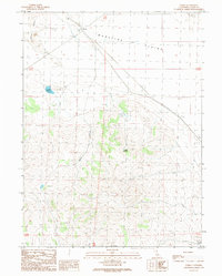
1989 Map of Termo
USGS Topo · Published 1989About this map
Termo sits at the western edge of the expansive Madeline Plains, a high-altitude basin where the Southern Pacific railroad line meets the highway. This late 1980s survey captures a sparse ranching and transportation landscape defined by the transition from the level floor of the plains to the broken terrain of Schott Canyon and the prominent Buttes to the northwest. The presence of the Cem near the northern boundary and localized water sources like Ducasse Reservoir and Tunnel Spring indicate the essential infrastructure required for settlement in this arid corner of Lassen County. The map also documents industrial activity through the Borrow Pit, while natural features like Fleming Spring mark the few reliable water points in the southern reaches of the quadrangle.
Find a feature on this map
13 named features on this map. Tap any name to fly to it.
Don’t see what you’re looking for? This feature index may not catch every label — zoom into the map to look around manually.
Map Details
Editions of this 1989 Termo Map
This is the sole edition of this map. No revisions or reprints were ever made.
Other maps of this area

1886 · Honey Lake
USGS Topo · 1:250,000

1891 · Honey Lake
USGS Topo · 1:250,000

1893 · Honey Lake
USGS Topo · 1:250,000

1954 · Karlo
USGS Topo · 1:62,500

1954 · Grasshopper Valley
USGS Topo · 1:62,500

1954 · Ravendale
USGS Topo · 1:62,500

1954 · Fredonyer Peak
USGS Topo · 1:62,500

1955 · Westwood
USGS Topo · 1:250,000

1958 · Westwood
USGS Topo · 1:250,000

1959 · Westwood
USGS Topo · 1:250,000