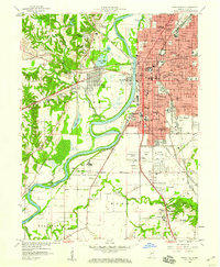
1958 Map of Terre Haute
USGS Topo · Published 1960About this map
The Wabash River carves a deep bend between the urban center of Terre Haute and the lowlands of West Terre Haute in this late 1950s survey. This map captures the city at a height of institutional development, showing the campus of the Indiana State Teachers College alongside major civic anchors like St Anthonys Hospital and the Courthouse. The riverfront is defined by heavy industry and utility, featuring the Dresser Power Plant and extensive rail yards of the Pennsylvania RR and New York Central RR. To the south, the Terre Haute Federal Penitentiary stands as a prominent landmark near the agricultural flats of Honey Creek. Smaller, outlying settlements like Toad Hop and Ferguson Hill provide a look at the residential expansion and local topography surrounding the city's primary industrial and transport corridors.
Find a feature on this map
94 named features on this map. Tap any name to fly to it.
Don’t see what you’re looking for? This feature index may not catch every label — zoom into the map to look around manually.
Map Details
Editions of this 1958 Terre Haute Map
3 editions found
Other maps of this area

1932 · Marshall
USGS Topo · 1:62,500

1937 · Marshall
USGS Topo · 1:62,500

1940 · Lewis
USGS Topo · 1:24,000

1940 · Pimento
USGS Topo · 1:24,000

1941 · Seelyville
USGS Topo · 1:24,000

1941 · Terre Haute
USGS Topo · 1:24,000

1942 · Hutton
USGS Topo · 1:24,000

1942 · Dennison
USGS Topo · 1:24,000

1947 · Paris
USGS Topo · 1:62,500

1948 · Terre Haute
USGS Topo · 1:24,000