
1918 Map of Terrebonne
USGS Topo · Published 1918About this map
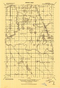
The Red Lake River and Clearwater River define the hydraulic character of this northern Minnesota landscape, where an extensive network of ditches indicates early twentieth-century efforts to drain the marshy terrain for agriculture. Compiled as a progressive military map, the sheet captures the region during a period of steady rail expansion, with the Great Northern and the Minneapolis St. Paul and Sault Ste. Marie railroads intersecting near the settlement of Plummer. Small rural nodes like Terrebonne and Brooks serve as local hubs, surrounded by numerous unidentified schools and a small church that reflect the scattered homesteading pattern of the era. The map also records the political landscape at the junction of the Pennington, Red Lake, and Polk county lines.
Find a feature on this map
25 named features on this map. Tap any name to fly to it.
Don’t see what you’re looking for? This feature index may not catch every label — zoom into the map to look around manually.
Map Details
Editions of this 1918 Terrebonne Map
2 editions found
Other maps of this area

1918 · Red Lake Falls
USGS Topo · 1:62,500

1918 · Viking
USGS Topo · 1:62,500

1919 · Grit
USGS Topo · 1:62,500

1919 · Valley
USGS Topo · 1:62,500

1943 · Thief River Falls
USGS Topo · 1:62,500

1952 · Red Lake Falls
USGS Topo · 1:62,500

1952 · Grand Forks
USGS Topo · 1:250,000

1952 · Thief River Falls
USGS Topo · 1:250,000

1954 · Bemidji
USGS Topo · 1:250,000

1954 · Roseau
USGS Topo · 1:250,000