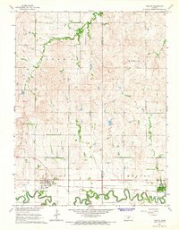
1965 Map of Tescott
USGS Topo · Published 1966About this map
The Saline River winds in tight, serpentine oxbows across the southern portion of this mid-1960s survey, defining the agricultural character of the border between Lincoln and Ottawa counties. The small riverside communities of Beverly and Tescott serve as the primary anchors for the region, both positioned along the Union Pacific railroad corridor that mirrors the river's valley. This survey captures a rural Kansas landscape where the transition from the high, dissected terrain of Logan and Henry townships to the alluvial flats is marked by numerous small cemeteries, including Spring Creek Cem, Twin Hills Cem, and Price Cem. The presence of a Gravel Pit and Quarry suggests a reliance on local mineral resources for infrastructure, while the extensive creek systems like Spring Creek highlight the drainage patterns feeding into the Saline.
Find a feature on this map
19 named features on this map. Tap any name to fly to it.
Don’t see what you’re looking for? This feature index may not catch every label — zoom into the map to look around manually.
Map Details
Editions of this 1965 Tescott Map
This is the sole edition of this map. No revisions or reprints were ever made.
Other maps of this area

1892 · Salina
USGS Topo · 1:125,000

1892 · Minneapolis
USGS Topo · 1:125,000

1894 · Ellsworth
USGS Topo · 1:125,000

1894 · Beloit
USGS Topo · 1:125,000

1942 · Salina
USGS Topo · 1:125,000

1955 · Culver
USGS Topo · 1:24,000

1955 · Manhattan
USGS Topo · 1:250,000

1955 · Great Bend
USGS Topo · 1:250,000

1955 · Hutchinson
USGS Topo · 1:250,000

1955 · Beloit
USGS Topo · 1:250,000