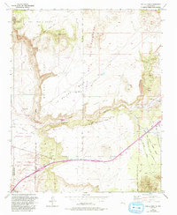
1953 Map of Tetilla Peak
USGS Topo · Published 1993About this map
Tetilla Peak and the volcanic terrain of the Rio Plateau dominate this landscape, where the high desert is defined by significant land grants and early transport corridors. The Santa Fe River cuts through the center, carving out the Cañada de Santa Fe as it descends toward the Cochiti Indian Reservation. This map reveals a complex web of historical property boundaries, including the Caja del Rio Grant, La Majada Grant, and Mesita de Juana Lopez Grant. The presence of the La Bajada Mine and various cinder pits reflects the area's geological and industrial utility during the mid-20th century. Settlement is concentrated at La Bajada and La Cienega, where Cienega Creek provides a vital water source in an otherwise arid environment marked by numerous wells, such as the Eight Hundred Foot Well.
Find a feature on this map
43 named features on this map. Tap any name to fly to it.
Don’t see what you’re looking for? This feature index may not catch every label — zoom into the map to look around manually.
Map Details
Editions of this 1953 Tetilla Peak Map
5 editions found
Other maps of this area

1892 · San Pedro
USGS Topo · 1:125,000

1892 · Santa Clara
USGS Topo · 1:125,000

1951 · Agua Fria
USGS Topo · 1:24,000

1951 · Turquoise Hill
USGS Topo · 1:24,000

1952 · Turquoise Hill
USGS Topo · 1:24,000

1952 · Montoso Peak
USGS Topo · 1:24,000

1953 · Cochiti Dam
USGS Topo · 1:24,000

1953 · Santo Domingo Pueblo
USGS Topo · 1:24,000

1953 · Tetilla Peak
USGS Topo · 1:24,000

1953 · Agua Fria
USGS Topo · 1:62,500