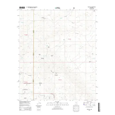
2013 Map of Texas Hill
USGS Topo · Published 2013About this map
Armstrong and Armstrong Ranch sits at the northern edge of this high-altitude landscape, where the Chihuahuan Desert meets the foothills. The terrain is defined by a series of significant drainage systems and canyons, including Box Canyon and Seco Canyon, which cut through the limestone as they move eastward across the Otero and Eddy County line. The distribution of water resources such as Secrest Waterhole, New Dirt Tank, and Texas Hill Lake indicates a landscape heavily managed for livestock and seasonal grazing.
Find a feature on this map
39 named features on this map. Tap any name to fly to it.
Don’t see what you’re looking for? This feature index may not catch every label — zoom into the map to look around manually.
Map Details
Editions of this 2013 Texas Hill Map
This is the sole edition of this map. No revisions or reprints were ever made.
Other maps of this area

1940 · Bandanna Point
USGS Topo · 1:62,500

1943 · Bandanna Point
USGS Topo · 1:62,500

1943 · Texas Hill
USGS Topo · 1:62,500

1945 · Texas Hill
USGS Topo · 1:62,500

1954 · Carlsbad
USGS Topo · 1:250,000

1957 · Box Canyon Ranch
USGS Topo · 1:24,000

1958 · Carlsbad
USGS Topo · 1:250,000

1978 · Strychnine Draw
USGS Topo · 1:24,000

1978 · Artesia
USGS Topo · 1:100,000
1978 · South Taylor Tank
USGS Topo · 1:24,000