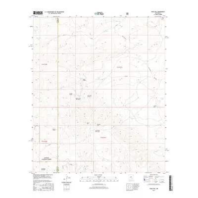
2017 Map of Texas Hill
USGS Topo · Published 2017About this map
Texas Hill rises as a central landmark within this high-desert landscape, situated along the boundary of Otero and Eddy counties. The terrain is defined by a series of deep drainages including Box Canyon in the north and the complex systems of North Texas Hill Canyon and South Texas Hill Canyon. Water management is the primary human imprint on this arid environment, evidenced by an extensive network of named livestock tanks and waterholes such as Segrest Waterhole, New Dirt Tank, and McGonigle Tanks. To the south, the map transition into the northern reaches of the Lincoln National Forest, where the foothills of the Guadalupe Mountains begin to take shape. The presence of features like Texas Hill Lake and Acrey Lake alongside ephemeral washes such as Cawley Draw highlights the vital role of seasonal water catchments for local ranching operations in this part of New Mexico.
Find a feature on this map
35 named features on this map. Tap any name to fly to it.
Don’t see what you’re looking for? This feature index may not catch every label — zoom into the map to look around manually.
Map Details
Editions of this 2017 Texas Hill Map
This is the sole edition of this map. No revisions or reprints were ever made.
Other maps of this area

1940 · Bandanna Point
USGS Topo · 1:62,500

1943 · Bandanna Point
USGS Topo · 1:62,500

1943 · Texas Hill
USGS Topo · 1:62,500

1945 · Texas Hill
USGS Topo · 1:62,500

1954 · Carlsbad
USGS Topo · 1:250,000

1957 · Box Canyon Ranch
USGS Topo · 1:24,000

1958 · Carlsbad
USGS Topo · 1:250,000

1978 · Strychnine Draw
USGS Topo · 1:24,000

1978 · Artesia
USGS Topo · 1:100,000
1978 · South Taylor Tank
USGS Topo · 1:24,000