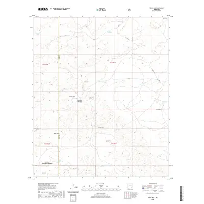
2020 Map of Texas Hill
USGS Topo · Published 2020About this map
Texas Hill rises as a prominent landmark in this desert landscape along the border of Otero and Eddy counties. The map documents a critical network of water management features essential for ranching and survival in the high desert, including Segrest Waterhole, Acrey Lake, and Texas Hill Lake. These man-made and natural catchments are linked by a rugged topography of drainages like Cawley Draw and Fanning Draw, which carve through the limestone terrain toward the Guadalupe Mountains. Within the boundaries of the Lincoln National Forest, the map shows a quiet, working landscape defined by named canyons such as Box Canyon, Seco Canyon, and Nester Canyon. The presence of numerous stock tanks, including New Dirt Tank and Larrimore Tank, underscores the area's continued use for livestock grazing in an environment where every named water source is a vital geographic marker.
Find a feature on this map
30 named features on this map. Tap any name to fly to it.
Don’t see what you’re looking for? This feature index may not catch every label — zoom into the map to look around manually.
Map Details
Editions of this 2020 Texas Hill Map
This is the sole edition of this map. No revisions or reprints were ever made.
Other maps of this area

1940 · Bandanna Point
USGS Topo · 1:62,500

1943 · Bandanna Point
USGS Topo · 1:62,500

1943 · Texas Hill
USGS Topo · 1:62,500

1945 · Texas Hill
USGS Topo · 1:62,500

1954 · Carlsbad
USGS Topo · 1:250,000

1957 · Box Canyon Ranch
USGS Topo · 1:24,000

1958 · Carlsbad
USGS Topo · 1:250,000

1978 · Strychnine Draw
USGS Topo · 1:24,000

1978 · Artesia
USGS Topo · 1:100,000
1978 · South Taylor Tank
USGS Topo · 1:24,000