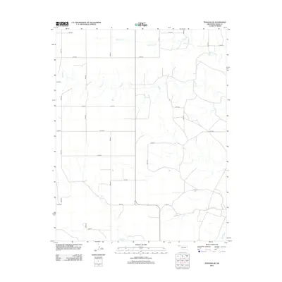
2012 Map of Texhoma NE
USGS Topo · Published 2012About this map
Beaver River winds through the southeastern corner of this High Plains landscape in Texas County, defining the drainage patterns for the surrounding panhandle terrain. This 2012 survey reveals a highly organized section-line road grid, including Co Hwy-49, which overlays a territory etched by seasonal watercourses. Significant intermittent streams such as Tepee Cr and Spring Aroa Cr provide the primary topographic relief, carving shallow draws across the agricultural plateau. The map details the transition between the upland prairie and the river bottomlands near Sand Cr, offering a clear view of the modern rural infrastructure and land management typical of the Oklahoma Panhandle in the early 21st century.
Find a feature on this map
24 named features on this map. Tap any name to fly to it.
Don’t see what you’re looking for? This feature index may not catch every label — zoom into the map to look around manually.
Map Details
Editions of this 2012 Texhoma NE Map
This is the sole edition of this map. No revisions or reprints were ever made.
Other maps of this area

1954 · Perryton
USGS Topo · 1:250,000

1958 · Perryton
USGS Topo · 1:250,000

1973 · Texhoma NE
USGS Topo · 1:24,000

1973 · Texhoma North
USGS Topo · 1:24,000

1973 · Goodwell NW
USGS Topo · 1:24,000

1973 · Eva SE
USGS Topo · 1:24,000
1973 · Texhoma SW
USGS Topo · 1:24,000

1973 · Hough SW
USGS Topo · 1:24,000
1973 · Texhoma NW
USGS Topo · 1:24,000

1973 · Goodwell
USGS Topo · 1:24,000