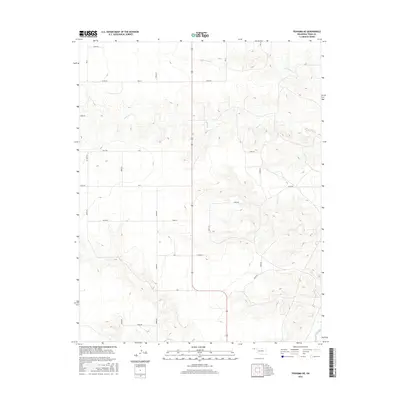
2016 Map of Texhoma NE
USGS Topo · Published 2016About this map
The High Plains landscape of Texas County reveals a stark, rural character dominated by an intricate grid of section roads and seasonal drainage systems. Central to this topography is the meandering path of Tepee Cr, which cuts through the undulating terrain alongside Spring-Area Cr in the northern portion of the quadrangle. The 2016 survey illustrates the precision of modern land division, where arterial routes such as E0180 Rd and E0260 Rd define the boundaries of large agricultural tracts typical of the Oklahoma Panhandle. This area lacks concentrated settlements, showing instead a dispersed pattern of land use where Sand Cr and various unnamed draws provide the only relief from the geometric regularity of the road network.
Find a feature on this map
21 named features on this map. Tap any name to fly to it.
Don’t see what you’re looking for? This feature index may not catch every label — zoom into the map to look around manually.
Map Details
Editions of this 2016 Texhoma NE Map
This is the sole edition of this map. No revisions or reprints were ever made.
Other maps of this area

1954 · Perryton
USGS Topo · 1:250,000

1958 · Perryton
USGS Topo · 1:250,000

1973 · Texhoma NE
USGS Topo · 1:24,000

1973 · Texhoma North
USGS Topo · 1:24,000

1973 · Goodwell NW
USGS Topo · 1:24,000

1973 · Eva SE
USGS Topo · 1:24,000
1973 · Texhoma SW
USGS Topo · 1:24,000

1973 · Hough SW
USGS Topo · 1:24,000
1973 · Texhoma NW
USGS Topo · 1:24,000

1973 · Goodwell
USGS Topo · 1:24,000