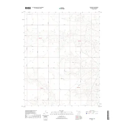
2018 Map of Texhoma NE
USGS Topo · Published 2018About this map
Tepee Cr and Spring Area Cr carve a complex network of drainages across this section of the Oklahoma Panhandle, illustrating the rugged breaks that lead down toward the Beaver River valley. This 2018 survey shows a landscape defined by its section-line grid, where routes like Road S and n0660 RD bisect large tracts of open country. The intersection of Co Hwy 49 and e0210 RD provides a navigational anchor in an area primarily used for ranching and agriculture. In the southern reaches, Sand Cr joins the larger drainage system, highlighting the hydraulic importance of these seasonal waterways in Texas County. The map provides a clear look at the township and range boundaries, including t3n r11e and t2n r12e, which have structured land ownership in this region since the original land runs.
Find a feature on this map
33 named features on this map. Tap any name to fly to it.
Don’t see what you’re looking for? This feature index may not catch every label — zoom into the map to look around manually.
Map Details
Editions of this 2018 Texhoma NE Map
This is the sole edition of this map. No revisions or reprints were ever made.
Other maps of this area

1954 · Perryton
USGS Topo · 1:250,000

1958 · Perryton
USGS Topo · 1:250,000

1973 · Texhoma NE
USGS Topo · 1:24,000

1973 · Texhoma North
USGS Topo · 1:24,000

1973 · Goodwell NW
USGS Topo · 1:24,000

1973 · Eva SE
USGS Topo · 1:24,000
1973 · Texhoma SW
USGS Topo · 1:24,000

1973 · Hough SW
USGS Topo · 1:24,000
1973 · Texhoma NW
USGS Topo · 1:24,000

1973 · Goodwell
USGS Topo · 1:24,000