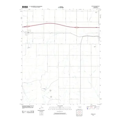
2010 Map of Texola
USGS Topo · Published 2010About this map
Texola sits at the western edge of Oklahoma, showing the grid-patterned settlement and surrounding agricultural landscape near the Texas border. This 2010 survey highlights the rural infrastructure and water management systems necessary for this arid plains region, featuring a series of catchments including Oren Number 1 Dam, Oren Number 2 Dam, and Oren Number 3 Dam. These engineered features support the drainage basins of Little Turkey Creek and Fish Creek. Genealogists and local historians can locate established burial sites such as Davis Cemetery and Texola Cemetery. The terrain is also marked by Haddock Field and a network of section-line roads, such as E 1250 RD and N 1700 RD, which define the ranching and farming boundaries of the area.
Find a feature on this map
29 named features on this map. Tap any name to fly to it.
Don’t see what you’re looking for? This feature index may not catch every label — zoom into the map to look around manually.
Map Details
Editions of this 2010 Texola Map
This is the sole edition of this map. No revisions or reprints were ever made.
Other maps of this area

1954 · Amarillo
USGS Topo · 1:250,000

1955 · Clinton
USGS Topo · 1:250,000

1957 · Clinton
USGS Topo · 1:250,000

1958 · Amarillo
USGS Topo · 1:250,000

1960 · Sweetwater
USGS Topo · 1:62,500

1961 · Erick
USGS Topo · 1:62,500

1962 · Kelton SE
USGS Topo · 1:24,000

1963 · Fulller
USGS Topo · 1:24,000

1963 · Little Wolf Creek
USGS Topo · 1:24,000
1983 · Shamrock
USGS Topo · 1:100,000