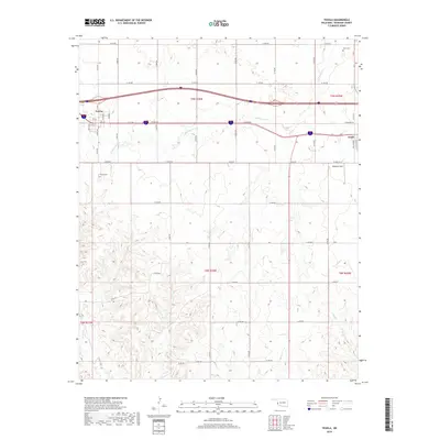
2018 Map of Texola
USGS Topo · Published 2018About this map
Texola sits at the western edge of Oklahoma on this 2018 survey, reflecting its long history as a gateway on the state line. The landscape is defined by a dense grid of section roads and the winding paths of seasonal waterways such as Little Turkey Cr and Bull Cr. To the east, the map captures the outskirts of Erick, showing the transition from the town's street grid into the surrounding rural tracts. Genealogists will find the locations of local burial grounds clearly marked, including Texola Cem and Davis Cem, while aviation history is represented by Haddock Field. The mapping of these small creek systems like Fish Cr and Turkey Cr illustrates the drainage patterns through Beckham County's plains, where the Interstate corridor now overlays the older township and range lines established by the Public Land Survey System.
Find a feature on this map
50 named features on this map. Tap any name to fly to it.
Don’t see what you’re looking for? This feature index may not catch every label — zoom into the map to look around manually.
Map Details
Editions of this 2018 Texola Map
This is the sole edition of this map. No revisions or reprints were ever made.
Other maps of this area

1954 · Amarillo
USGS Topo · 1:250,000

1955 · Clinton
USGS Topo · 1:250,000

1957 · Clinton
USGS Topo · 1:250,000

1958 · Amarillo
USGS Topo · 1:250,000

1960 · Sweetwater
USGS Topo · 1:62,500

1961 · Erick
USGS Topo · 1:62,500

1962 · Kelton SE
USGS Topo · 1:24,000

1963 · Fulller
USGS Topo · 1:24,000

1963 · Little Wolf Creek
USGS Topo · 1:24,000
1983 · Shamrock
USGS Topo · 1:100,000