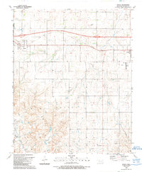
1989 Map of Texola
USGS Topo · Published 1989About this map
The Texas Oklahoma state line bisects this landscape, where the town of Texola sits directly on the border. By the late 1980s, the area reflects a transition from traditional transport to an energy-focused economy. An Old Railroad Grade traverses the northern section, tracing a path through Little Turkey Creek towards the settlement of Erick in the east. The southern terrain, characterized by the Dabney and Richland areas, is heavily marked by industrial activity, specifically numerous Gas Wells and a Pipeline network. Local history is anchored by the Texola Cem and Davis Cem, while modern developments like the Haddock Airport and a Golf Course near Erick indicate shifting land use. The drainage patterns of North Elm Creek and Bull Creek provide the primary natural structure to this prairie landscape.
Find a feature on this map
20 named features on this map. Tap any name to fly to it.
Don’t see what you’re looking for? This feature index may not catch every label — zoom into the map to look around manually.
Map Details
Editions of this 1989 Texola Map
This is the sole edition of this map. No revisions or reprints were ever made.
Other maps of this area

1954 · Amarillo
USGS Topo · 1:250,000

1955 · Clinton
USGS Topo · 1:250,000

1957 · Clinton
USGS Topo · 1:250,000

1958 · Amarillo
USGS Topo · 1:250,000

1960 · Sweetwater
USGS Topo · 1:62,500

1961 · Erick
USGS Topo · 1:62,500

1962 · Kelton SE
USGS Topo · 1:24,000

1963 · Fulller
USGS Topo · 1:24,000

1963 · Little Wolf Creek
USGS Topo · 1:24,000
1983 · Shamrock
USGS Topo · 1:100,000